
http://kalimpongonlinenews-articles-kpc.blogspot.com/2009/11/kalimpong-news-know-about-kalimpong.htmlKALIMPONG HOME>>>
Altitude: 1250 metres (4, I00 feet)
Population: 41,000
Climate: Temperate
Summer: M ax 27° Min 17.2 °
Winter: Max 15° /Min 17.2°
Rainfall: 86.2 inches annually (220 cm.)
Main Languages Spoken: Nepali,English, Bengali,Hindi

CONFLUENCE OF TEESTA AND RANGIT (Photo: Sankara)

GOLF COURSE DURBIN KALIMPONG (Photo: Arjit)

KATHERINE GRAHAM MEMORIAL CHAPEL, DG HOMES, KALIMPONG

HANUMAN MANDIR NEAR DEOLO KALIMPONG
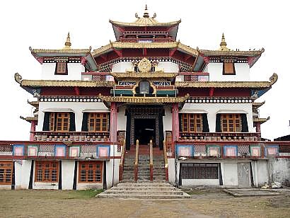
Zangdokpalri Monastry, Durpin Kalimpong

White Water Rafting in River Teesta
Science Center,Deolo (Photo:Utpal)
Kalimpong is a hill station (a hill town) nestled in the Shiwalik Hills (or Lower Himalaya) in the Indian state of West Bengal. It is located at 27.06° N 88.47° E at an average elevation of 1,247 m (4,100 feet). The town is the headquarters of the Kalimpong subdivision, a part of the district of Darjeeling. A major forward base of the Indian Army is located on the outskirts of the town.
Kalimpong is well known for its many educational institutions, which attract students from all over North East India, West Bengal, Bhutan, Nepal, and Bangladesh. Some of these famous good education institutes are Dr. Graham's Homes (co-ed, existing for more than 100 years, 500 acres (2.0 km²) of land), St. Augustine School (only for boys), St. Joseph Convent (for girls only), Rockvale Academy (co-ed). In recent times, Kalimpong has become an important tourist destination owing to its temperate climate and proximity to popular tourist locations in the region. Kalimpong is famous for its flower market, especially the wide array of orchids. It also houses several Buddhist monasteries which hold a number of rare Tibetan Buddhist scriptures.
The precise etymology of the name Kalimpong remains unclear. The most widely accepted origin of the name Kalimpong is "Assembly (or Stockade) of the King's Ministers" in Tibetan, derived from kalon ("King's ministers") and pong("stockade").[1]Another possible origin to the name comes from the translation "ridges where we play" from Lepcha, derived from the region's traditional tribal gathering for summer sporting events.[1] People from the hills also call the areaKalibong ("the black spurs").[1]
According to K.P. Tamsang, author of The Untold and Unknown Reality about the Lepchas, the term Kalimpong is deduced from the name Kalenpung, which in Lepcha means "Hillock of Assemblage";[2] in time, the name was distorted toKaleebung and later corrupted to Kalimpong. Another possible derivation points to Kaulim, a fibrous plant found in profusion in the region.[1]
The above etymologies point to the original pronunciation as ka-ley-bong which later got corrupted to Kalimpong, most probably due to the inability of the British to pronounce the word.
Kalimpong was periodically ruled by the kingdoms of Sikkim and Bhutan until the mid-19th century. In the 18th century, the place served as a Bhutanese forward location facing the Teesta Valley, until the end of the Anglo-Bhutan war in 1864 when the Treaty of Sinchula was signed, handing over this Bhutanese region to the British East India Company in 1865. This territory was then included into the district of Darjeeling as a sub-division of the Western Dooars.
Its close proximity to the Jelepla and Nathula passes increased its popularity for migrants from Nepal in search of jobs hence, increasing the populace of the area. The same reason opened many trade opportunities for the people in terms of fur, wools and grains between Tibet and India, a la the Silk Route of yore. The 1959 annexation of Tibet by China led to a growing population of escaped Buddhists monks to Kalimpong who built monasteries and brought many ancient scriptures as well. In 1976, the visiting Dalai Lama consecrated the Zang Dhok Palri Phodang monastery, which houses many of the scriptures.
Before these changes occurred, Kalimpong was a small hamlet with a scattered population of the native Lepcha community along with a few of the itinerant Limbu and Bhutia tribes. Kalimpong is also well known for its many prestigious educational institutes and schools which were brought to the place by Scottish Missionaries. After the Partition of Bengal following India’s Independence, Kalimpong was formally declared to be included in the state of West Bengal. The town was an alternative hill station for the British besides Darjeeling as a summer getaway from the sweltering heat of the plains.
Between 1986 and 1988, the demand for a separate state of Gorkhaland based on ethnic lines grew strong. Riots between the Gorkha National Liberation Front(GNLF), led by C K Pradhan, and the West Bengal government reached a standoff after a forty-day strike. The town was virtually under a siege, leading the state government to call in the Indian army to maintain law and order.This led to the formation of the Darjeeling Gorkha Hill Council, a body that was given semi-autonomous powers to govern the Darjeeling district, except the area under the Siliguri subdivision. Since 2007, the demand for a separate Gorkhaland state has been revived by the Gorkha Janmukti Morcha and its supporters in the Darjeeling hills.[14] The Kamtapur People's Party and its supporters' movement for a separate Kamtapur state covering North Bengal have also gained momentum.[15]Though Kalimpong is now peaceful, the issue of a separate state still lingers. In July 2004, the generally tranquil town was catapulted into national and international headlines after Maninder Pal Singh Kohli, a murderer wanted by Scotland Yard, was traced and found to be residing in Kalimpong.[4]

GEOGRAPHICAL LOCATION: The town centre is located on a ridge connecting two hills, Deolo Hill and Durpin Hill, at an elevation of 1,247 m (4,091 ft). Deolo, the highest point in Kalimpong, has an altitude of 1,704 m (5,590 ft) and Durpin Hill is at an elevation of 1,372 m (4,501 ft). The River Teesta flows in the valley below and separates Kalimpong from the state of Sikkim. The Shiwalik Hills, like most of the Himalayan foothills, have steep slopes and soft, loose topsoil, leading to frequent landslides in the monsoon season. The hills are nestled within higher peaks and the snow-clad Himalayan ranges tower over the town in the distance. Mount Kanchenjunga at 8,591 m (28,185 ft) the world's third tallest peak, is clearly visible from Kalimpong.
Many locales in Kalimpong are named based on its distance in miles fromTeesta Bazaar, a town which lies on the Teesta River in the valley below. For example, the locale 13th mile would be situated at a distance of 13 miles (21km) from Teesta Bazaar.
CLIMATE: Kalimpong has five distinct seasons: spring, summer, autumn, winter and the monsoons. Summers are mild, with the highs usually never crossing 30 °C (86 °F), and last between May and June. Summers are followed by the monsoon rains which lash the town between June and September. The monsoons are severe, often causing landslides which sequester the town from the rest of India. Winter lasts from December to February, with the maximum temperature being around 15 °C (59 °F). During the monsoon and winter seasons, Kalimpong is often enveloped by fog. The annual temperature ranges from a high of 30 °C to a low of −4 °C (25 °F).
ECONOMY: The most significant contributor to the Kalimpong economy is tourism. The summer and spring seasons are the most popular with tourists, keeping many of Kalimpong's residents employed directly and indirectly. The town—earlier an important trade post between India and Tibet—hopes to boost its economy after the reopening of the Nathu La pass in April 2006.[21] Though this has resumed Indo–China border trades,[22] it is expected that Kalimpong will have a better chance of revival as a hub for Indo–China trades if the demand of local leaders for reopening of Jelep La pass also is met.[22]
Farming on terraced slopes is a major source of livelihood for its rural populace and it supplies the town with fruits and vegetables. Kalimpong is a major ginger growing area of India. Kalimpong and the state of Sikkim together contribute 15 percent of ginger produced in India.[23] The Darjeeling Himalayan hill region is internationally famous for itstea industry.[24] However, most of the tea gardens are on the western side of Teesta river (towards the town of Darjeeling) and so tea gardens near Kalimpong contribute only 4 percent of total tea production of the region. In Kalimpong division, 90 percent of land is cultivable but only 10 percent is used for tea production.[25]
Education used to be the primary driver of the economy of the town but in recent years its contributions to the economy have stagnated. Many establishments cater to the Indian army base near the town, providing it with essential supplies. Small contributions to the economy come by the way of the sale of traditional arts and crafts of Sikkim and Tibet. Government efforts related to sericulture, seismology, fisheries etc. provide a steady source of employment to many of its residents. Kalimpong is well known for its flower export industry[5] – especially for its wide array of indigenous orchids and gladioli.
As the economic mainstay of Kalimpong is its many schools, these schools besides imparting education to the locals also cater to a significant number of students from the plains, the neighbouring state of Sikkim and also foreign countries such as Bhutan, Bangladesh, Nepal and Thailand. Besides providing livelihood to those directly involved with education, such as teachers, paying guest-keepers and other school staff, they also provide a good source of income to book sellers, hawkers, canteen wallahs, restaurant owners, garment sellers and drivers. In fact during the winters when schools shut for vacations, the economy of the town goes into a low scale hibernation mode.
Kalimpong is well renowned for its cheese, noodles and lollipops. Kalimpong also exports a wide range of traditional handicrafts, wood-carvings, embroidered items, bags and purses with tapestry work, copper ware, scrolls, Tibetan jewellery and artifacts.[27][28]
The Tharpa Choling Monastery, located at Tirpai Hill near Kalimpong, is managed by Yellow Hat sect and has a library of Tibetan manuscripts and thankas.[67]
Flower Nurseries in Kalimpong: The climate of Kalimpong is ideal for the cultivations of horticultural plants. Kalimpong is the only place where many commercial flower nurseries are situated. One should visit the beautiful laid out 'Universal Nursery' about 3 km from the town, on the Kalimpong-Teesta road to have a glimpse of the fabulous Cactus, Orchid, Amaryllis (only in April and May), Succulents and many other flowers. The other nurseries are also equally attractive. Sri Ganesh Mani Pradhan Nursery at 12th Mile is specially renowned for its varieties of orchids. If one is interested in Gladioli, you must meet Col. Tulsi Pradhan, Murgi Hatta, below Motor Stand, Kalimpong. He is an expert in Gladioli. If you are interested in Rose, Gerbera and Dahlias you can visit Standard Nursery at Chibo Busty, Kalimpong, the other nurseries which are also of equal importance are Sri L.B. Pradhan Nursry, Twin Brothers Nursery and Flower Wood Nursery.
MEDIA:Kalimpong receives almost all the television channels that are received in the rest of India. Cable Television serves most of the homes in the city, while satellite television is more common in the outlying areas. Besides mainstream Indian channels, Kalimpong also receives locally produced Nepali language channels like Hill Channel, Kalimpong Television KTv, Dainandini, Haal Khabar etc. through the local cable network.Of these channels some including Dainandini produces Daily news. Dainadini is a unit of Kalimpong Press Club and news based channel that transmit 30 mins news twice daily at 7am and 7pm. Newspapers in Kalimpong include English language dailies, The Statesman and The Telegraph, which are printed in Siliguri,[60][61] and The Economic Times and the Hindustan Times which are printed in Kolkata(Calcutta).[62] Among other languages, Nepali, Hindi and Bengali are prominent vernacular languages used in this region.[19] Newspapers in all these four languages are available in the Darjeeling Hills region. Of the largely circulated Nepali newspapers Himalay Darpan, Sunakhari Samachar are read most.[62] The Tibet Mirror was the first Tibetan language newspaper published in Kalimpong in 1925.[63]
Internet service and Internet cafés are well established; these are mostly served through broadband, data card of different mobile services, WLL,dialup lines ,[64] [65] The public radio station, All India Radio along with other National and Private Channels including FM Radio are received in Kalimpong. The area is well serviced by major telecommunication companies of India with all types of cellular services in almost all the areas.[66]
CULTURE: The predominant people group here would be Nepali, so those of you who may have had the priviledge to go to Nepal have already tasted Nepali culture. Other people groups would be Tibetans, Bhutanese, Lepchas and Bengalis.
A small trading town in the Eastern Himalayas, Kalimpong sits strategically near the borders of Sikkim, Bhutan, Tibet and Nepal. A cross roads of culture and people can be found here, including Buddhists, Hindus, and Christians among the Tibetans, Bhutanese, Sikkimese, Lepchas, Nepalis, and various Indian peoples. Set high on a ridge surrounded by thick forests, th the Rangit River in the valley to the west and the Relli River to the East.
JALDHAKA is one of the ...... For More CLICK HERE

Though there is a sizable population of Tibetans living in Kalimpong and even many business non-Tibetan communities are fluent in, the Tibetan language has been omitted which I want the website constructors to take note.
ReplyDeleteYes the Tibetan language is omitted by the website admin
ReplyDeletehey if u guys want tibetan language added to the website why dont u guys go back to tibet
ReplyDeleteList of educational institutions looks incomplete
ReplyDeletewithout mentioning S.U.M.I.(Scottish Universities Mission Institution)established in 1886 standing for more than 120 years on an area expanding more
than the area of Dr.Grahams Holmes
And yes Tibetan language is widely spoken and understood by the locals
SUMIAN